- News
- City News
- nagpur News
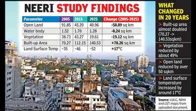
- Urban sprawl eats into green cover over 20 yrs: City’s surface heat surges to 52°C
Trending
Urban sprawl eats into green cover over 20 yrs: City’s surface heat surges to 52°C
End of Article
Follow Us On Social Media

Hot Picks
Top Trending
Tired of too many ads?go ad free now
Trending Stories
In Nagpur
In City
- Urban sprawl eats into green cover over 20 yrs: City’s surface heat surges to 52°C
- 'Sorry mummy, papa, I have ruined everything': NEET aspirant's note found days after suicide in Nagpur
- ‘Dead’ Woman Walking, AI To Find Woh Kaun Thi?
- Another accused held for money laundering
- Maha Leads The Day When India Installs Record 15k Solar Systems
- Family chokes on smoke, hides in loo to stay alive
- Base rates undersand extractionpolicy revised
- NMC To Plant 5L Trees In Year-long Green Drive, Gadkari To Launch Campaign On June 5
- 19 injured after bus ramstruck on Samruddhi e-way
- In-house IT cell to cut NU’s dependence on pvt players: VC to BJYM
- Eye on UP polls, Rahul Gandhi meets Dalit-EBC delegation
- 3 sacked Mumbai railway policemen arrested after pre-arrest bail cancelled by Supreme Court
- Tourism must drive jobs, growth, not just infrastructure: Yogi
- Two recruitment firm directors detained on charge of cheating aspiring techies
- Fuel pumps halt diesel sales in cans over confusing directives & enforcement fears
- NCP’s Kakade elected unopposed from Pune MLC seat; rebels heat up Jalgaon & Nashik contest; BJP vs NCP (SP) in Solapur
- Gangster Ghaywal’s brother Sachin arrested from Sikar in Rajasthan
- Four members of Mumbai family killed in road accident in Kolhapur
- PCMC demolishes illegal residential structure linked to hooch tragedy accused in Phugewadi
- Vacate ahead of monsoon, PMC tells occupants of 36 dilapidated wadas
Tired of too many ads?go ad free now


Explore Every Corner
Across The Globe
Jaxson DartDelhi Malviya Nagar Hotel FireUS Iran WarNFL Trade RumorsMaria sharapovaNHL Trade RumorAbhijeet DipkeConnor McDavidRussell Wilson and Ciara Combined Net WorthVictor WembanyamaRitshi ChodenAlastair CookJohn BoltonSerena WilliamsSuryakumar YadavWho is Tommy Paul FianceeHumayun KabirAaron RodgersDarren DregerFloyd Mayweather JrKylie KelceAryna Sabalenka and Georgios Combined Net WorthRussell Wilson and Ciara Net WorthVegas Golden KnightsNFL Trade RumorShedeur SandersDeclan Rice GirlfriendDiana ShnaiderMalviya Nagar Restaurant FireFIFA World Cup Squad

Hot on the Web
Dhurandhar 2 OTTSaif Ali KhanShah Rukh KhanSpanish ProverbRam CharanKangana RanautHeart HealthNushrratt BharucchaAhaan PandayMarjane Satrapi Death NewsShilpa ShindeArchana Puran SinghKedarnath DhamNushrratt BharucchaKheera VS KakdiZhang YimingPeddi ReviewProtein Powder RiskBarack Obama QuoteSouth Delhi Restaurant TragedyPeabo Bryson Death NewsDeepika PadukoneUpasana KamineniDrishyam 3 Box Office CollectionKaruppu Box Office CollectionDhurandhar 2 Box Office CollectionChand Mera Dil Box Office CollectionYashAjay DevgnHoroscope TodayDelhi Malviya Nagar Fire4th Squadron S-400India Sudarshan ChakraFirstcry CompensationIAF France Jet DealHuman Evolving On Tibetan PlateauLargest Islands In The WorldJellyfish That Never DiesGoogle Release MosquitoesDelivery Firm Refund DeniedNyt ConnectionsCaptions For Instagram Posts
Trending Topics
Kuldeep YadavDevdutt PadikkalKS Bharat RetirementDelhi Malviya Nagar Hotel FireSanjay ManjrekarNepal Cricket BoardAbhishek BanerjeePokimaneAnnamalaiFirhad HakimPat CumminsFIFA World Cup 2026Suryakumar YadavRussell Wilson Ciara Combined net worthHolly HolmNHL Trade RumorNFL Trade RumorTaylor SwiftUttarkashi Babita Pandey CaseKuwait airport drone attackIran WarDonald TrumpLos Angeles airport detentionJamshid GhomiPakistan Rape CaseIsrael Lebanon ceasefireOhio Car CrashFairfield High School ShootingSri Lanka Nursing Home FireMalviya Nagar Hotel FireBritish Lawmaker Sues Elon MuskGoogle Acknowledges Data CentersMustafa SuleymanNASA New WebsiteBill StaplesApple Nvidia ChipUltrahuman Data BreachHack Of The DayGarena Free Fire MAX Redeem CodesPeroxide CodesGenshin Impact Codes
Popular Categories
HeadlinesSports NewsBusiness NewsIndia NewsWorld NewsInternational SportsHealthBreaking NewsTravelAstrologyDeorhiTOI Young LeadersTOI Home Decor AwardsPower Creator Awards 2026TOI Ecopreneur Awards 2026Gold Rate TodayWeather TodaySilver Price TodayDelhi Weather TodayPetrol Price TodayDiesel Price TodayCNG Price TodayLPG Price TodayPetrol Price MumbaiDelhi AQIIs Bank Open TodayMumbai AQI TodayIs Bank Open TomorrowPublic Holidays in JuneBank Holidays in June
Trending Videos
'Don't Distort Facts': China Erupts As Rubio Challenges Beijing's 'Tiananmen Narrative'Knicks Vs. Spurs: Wild Brawl Breaks Out; Viral Video Shows Chaos In San Antonio As Fans Trade BlowsHUGE WIN! Putin's Men 'Reset' Ukraine Map; Russia Breaches Zelensky's ‘Impossible-to-Take’ Bastion'I Saw Four Bodies At One Spot': Local Hero Recounts Horror Of Delhi Fire | WatchShowdown Erupts: Thompson Rips Bessent's 'Golden Age Economy' Claims In US HouseJason Smith's Bold Move Turns Bessent Hearing Into Chaos | Watch'Did Not Tell Me...': RJD MP Breaks Silence On Helping Cockroach Janta Party In Holding PresserIndia's First Model Border Village In Ladakh: Can Chumur Strengthen India's China Frontier?Trump Goes On Unhinged 1AM Posting Spree With Bizarre Conspiracy Theory About 'Stolen' Votes'HEY YOU...YES YOU, BE QUIET': Trump Launches Personal Attack On CNN Reporter | FIERY CLASHTel Aviv Rocked By Deadly Car Blast; Police Rules Out Militant Connection, Woman DeadOn Cam: Putin Interrupts Ceremony To Fix Something On Foreign Minister's Jacket | WATCHJanhvi Kapoor Climbs 3,550 Steps Barefoot To Tirumala In Powerful Act Of Faith Viral Hit Trailer: Oji Suzuka and Ai Mikami starrer Viral Hit Official TrailerRajdip Gupta on T20 Mumbai League's vision, young talent & growthPrince William's Priceless Response To Young Fan Goes Viral'We Are No More In INDIA Bloc, Will Not Attend June 8 Meet': DMK After Congress 'Betrayal' In TNIndia's Savvy Cyprus, Armenia Play Pushes Turkey Into A Corner; Why Ankara Wants Reset In Ties
Latest News
Hazaribag man drowns while fishing in lake"Behen Darr Gayi!": Fans relive ‘Bhagam Bhag’ era after watching Akshay Kumar's 'Bhooth Bangla' trailerMBOSE HSLC result 2026 to release tomorrow: Check details hereIran war risk: JPMorgan CEO Jamie Dimon warns of oil shocks, sticky inflation and higher interest ratesMake your clutch last longer with these easy driving tips“Three-against-one situation”: El Rubius opens up on being “targeted” in MrBeast’s viral $1M challengeBihar BTSC lab assistant notification released for 1091 posts at btsc.bihar.gov.in; apply hereIPL craze costs techie Rs 1.46 lakh in fake RCB vs CSK ticket scamRaising “robot-proof” kids: Why creativity and curiosity matter more than everInside ‘Satguru Sharan’: Exploring Saif Ali Khan and Kareena Kapoor Khan’s Rs 100 crore Bandra homeHow selling Alaska in 1867 was a costly mistake for Russia'Hera Pheri 3 is coming': Paresh Rawal dismisses delay reports and reveals he will 'start shooting soon'US-Iran War: A daring rescue Hollywood blockbuster is on its way. Till then, pick your favourite from these 10 films on bringing someone home against all oddsKolkata team unveils fan mural at Rash Behari Avenue, celebrating city’s first loveHow US spread a lie to rescue a pilot of a jet shot down in IranNetflix unveils ‘VOID’, an AI model that can change a movie plotAI data centers are causing 'stress' not just to tech companies, but also private insurers"Trans women are.....": Clavicular’s viral moment with trans women sparks fresh conversation on internet culture
Copyright © 2026 Bennett, Coleman & Co. Ltd. All rights reserved. For reprint rights: Times Syndication Service